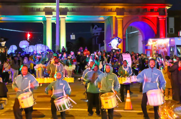
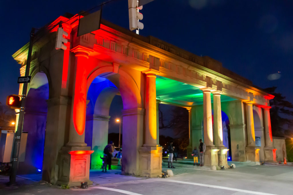
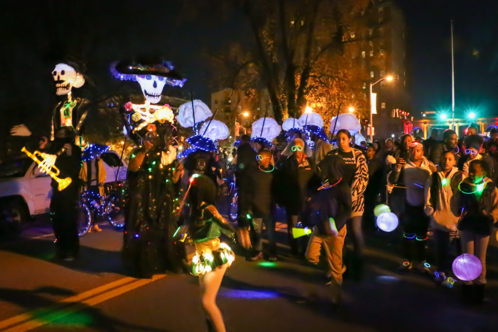
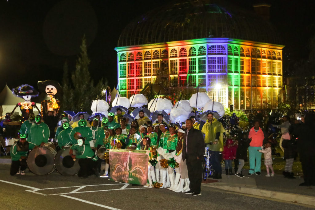
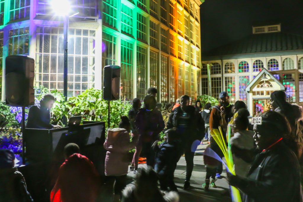
Showcasing the cherished connections between Druid Hill Park and surrounding neighborhoods, the Arches & Access project illuminated and activated the historic Druid Hill Park Gate at Madison Avenue, Druid Hill Park, and the Rawlings Conservatory with colorful lights, a community parade, and a public party. On the evening of November 3rd, 2019, over three hundred residents, artists, and performers transformed Madison Avenue at Druid Park Lake Drive into a spectacular, roving block party. Neighbors collectively created a place to march, dance, and perform in celebration of our West Baltimore communities united in green space and creating safe streets for people.
Arches & Access was a Neighborhood Lights Project presented as part of the Brilliant Baltimore / Light City festival of light and literature. The event was led by Reservoir Hill artist Jessy DeSantis, Reservoir Hill advocate Courtney Bettle, and Auchentoroly Terrace public artist Graham Coreil-Allen with major support from the Reservoir Hill Improvement Council, a grant from Baltimore Heritage, and volunteers from Beth Am Synagogue’s IFO organization. The Reservoir Hill mothers Bettle and DeSantis took inspiration from DeSantis’ colorful painting of the Arches when they came up with the idea of creating a light art project in early 2019. Later the two reached out to Coreil-Allen of Graham Projects to help realize the light art. Collectively they expanded the vision to include solar powered lights leading into the park, activated by a joyful community parade showing what life could be like without highways hindering pedestrian access to Druid Hill Park.
Graham Projects is honored to have been apart of creating Arches & Access and look forward to working again with our community partners on making this light art and parade an annual success.
I’m honored and humbled to announce that I have been awarded a 2018 Open Society Institute (OSI) Baltimore Community Fellowship providing me with eighteen months of funding and organizing support as I collaborate with residents on reconnecting our West Baltimore neighborhoods with Druid Hill Park. Through the Druid Hill Complete Streets project I will be working with my neighbors to ensure that a forthcoming Baltimore City Department of Transportation (DOT) planning effort is as reflective of community voices as possible as we seek to convert the dangerous barrier highways around Druid Hill Park into complete streets safe and accessible for all – especially the approximately 50% of area residents who do not drive. Complete Streets are streets designed and operated to be safe and accessible for all, including pedestrians, transit users, wheelchair riders, and people who rely on bicycles. During the fellowship I will be working with local youth to create traffic calming public art to slow down cars and improve pedestrian safety. Potential ideas include mural-filled crosswalks, artistic planters protecting pedestrians, and creative signs reminding motorists where pedestrians have the right-of-way.
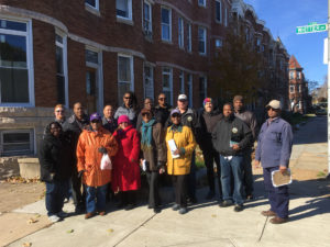
Auchentoroly Terrace community advocacy walk with city agencies, 2017.
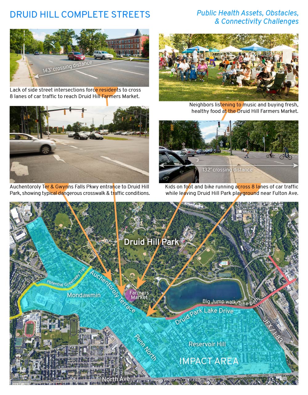
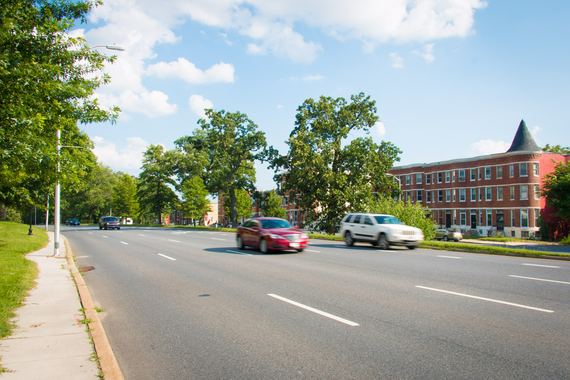
West Baltimore’s historic work class neighborhoods of color have systematically been denied safe access to Druid Hill Park due to dangerous six-to-nine-lane-wide highways constructed over community opposition between the 1940s and the 1960s. Click here to read my story about the history behind the highways cutting off the neighborhoods of Mondawmin, Penn North, and Reservoir Hill from Druid Hill Park. The formerly two-lane, park-front streets of Auchentoroly Terrace and Druid Park Lake Drive were widened into high-speed highways primarily serving suburban commuters at the expense of park access for local residents.
Structurally racist urban planning decisions to build highways around Druid Hill Park make it difficult for the residents to enjoy the park’s public health benefits, including exercise, healthy food, and clean air. The Baltimore City Health Department’s 2017 Neighborhood Health Profiles show that the majority working class, African American communities around the park have some of the city’s highest mortality rates of cardiovascular disease and cancer. Click here for the Penn North / Reservoir Hill and Greater Mondawmin health reports. Census data also shows that approximately half of residents in the immediate area code of 21217 do not drive. As pedestrians, transit users, wheelchair riders, and people who rely on bicycles, our residents deserve priority access to the park.
Since moving to Auchentoroly Terrace in 2013 I’ve listened to my neighbors talk about and experienced firsthand the need for more crosswalks, narrower roadways, less vehicular traffic, and slower speeds. With no playground in our neighborhood, I all too often witness small children on foot and bike darting across eight lanes of high speed traffic to reach the safe green spaces and play areas of Druid Hill Park. I also see how my retired, car-free neighbors are unable to reach the Druid Hill Farmers Market due to a lack of safe, convenient crosswalks. Most at risk are wheelchair riders who along sections of the park are blocked by non-ADA pathways.
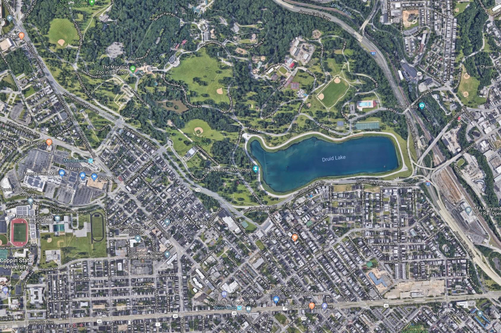
In response to community transportation needs, 7th District Councilman Leon F. Pinkett III convened the Druid Hill Park Stakeholders group in early 2017. The group includes representatives from Mondawmin, Auchentoroly Terrace, and Reservoir Hill; Baltimore City agencies including the Departments of Transportation, Public Works, and Recreation and Parks; as well as non-profits including Bikemore, Rails-to-Trails Conservancy, and Parks & People. We are also reaching out to more local leaders and organizations to bring into the planning and advocacy effort. Thanks to the councilman’s leadership, in February 2018 Baltimore City DOT agreed to conduct a major transportation study to address our community’s concerns. This study will build on two ongoing local initiatives, the Big Jump Baltimore and the Baltimore Greenway Trail Network northwest trail planning effort. As an OSI Community Fellow, I will work full-time with my neighbors to shape this forthcoming transportation plan for rebuilding the dangerous barrier-highways of Druid Park Lake Drive and Auchentoroly Terrace as accessible boulevards that safely connect our most vulnerable residents with Druid Hill Park.
The Druid Hill Complete Streets initiative will support community education, creative urban planning, and traffic calming through public art. We will organize community-led walking tours in which youth, seniors, wheelchair riders, elected officials, and city planners learn from one another while seeking common ground for enacting equitable park access. We will also creatively engage residents in the ongoing DOT planning process through a new website, social media campaign, and activities at places like the Druid Hill Farmers Market to get input from residents who may not be able to make traditional public meetings. Lastly, we will collaborate with youth to create traffic calming public art around Druid Hill Park based on community design workshops in which residents will identify sites for enhancing pedestrian safety and reconnecting with the park. These low-cost interventions will have an immediate positive impact on park connectivity and public health while enabling residents and the public at large to envision the possibilities for complete streets.
The schedule of events and public art production will be determined by the yet-to-be-confirmed DOT study timeline. The Druid Hill Complete Streets project will bring together diverse neighborhood groups to shape the upcoming improvements around the park, empowering communities to claim our public spaces through creative city planning and public art interventions.
Listen: Urban Planning History and Park Access in Druid Hill Park, Graham Coreil-Allen, Maryland Humanities podcast, August 30, 2018
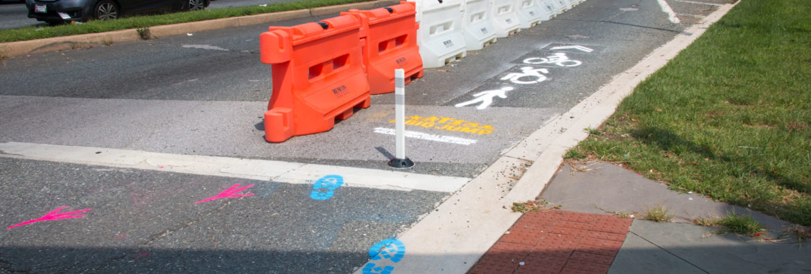
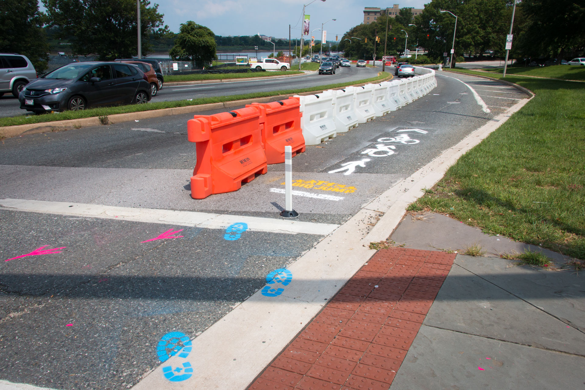
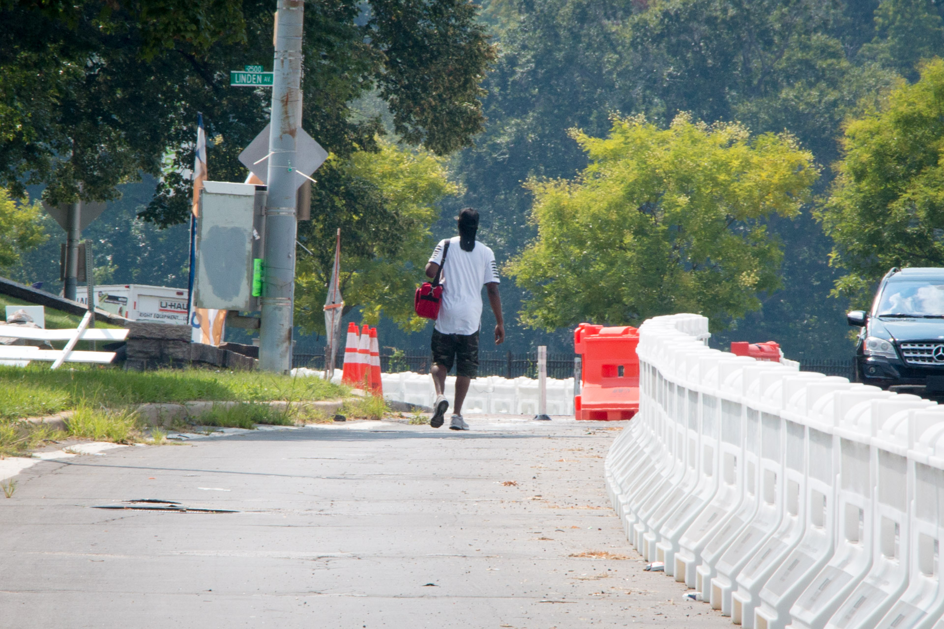
If you’ve recently visited Baltimore’s Druid Hill Park, you may have encountered a long row of orange and white plastic Jersey barriers running along the Druid Park Lake Drive and across the 28th Street Bridge. This is the Big Jump Baltimore shared-use path. Championed by local residents like myself, 7th District Councilman Leon Pinkett, Baltimore City Department of Transportation, and Bikemore, this temporary project counteracts decades of highway expansion with a protected space for pedestrians, wheelchair riders, and bicyclists to connect with green space, school, and jobs. Those of us living in West Baltimore certainly need it as for the past seventy years, walking or bicycling to Druid Hill Park has proven prohibitively dangerous. As a local resident and public artist, I’ve been working with neighbors on creating public art along the Big Jump pathway to make it safer for all people to enjoy the cultural and public health benefits of Druid Hill Park.
Half of residents around Druid Hill Park do not own cars. So why does the area feel like a suburban highway? From the 1940s through the 1960s, car-focused transportation projects drastically changed the face of the park. The city’s goal was faster commute times for downtown workers living in the suburbs. Back then the surrounding neighborhoods of Reservoir Hill and Mondawmin were largely Jewish and African American communities. Proposed in 1945, the “Druid Hill Expressway” would convert Druid Hill Avenue and McCulloh Street to one-way thoroughfares connecting with a widened and extended Auchentoroly Terrace. By 1947 the highway plans had sparked a robust public debate
When the “Druid Hill Expressway” was proposed, NAACP Labor Secretary Clarence Mitchell Jr. argued that increased traffic speeds through westside neighborhoods would imperil black residents effectively barred by racist real estate practices from moving to the very suburbs that the highway would serve. Shaarei Tfiloh synagogue Rabbi Nathan Drazin expressed concern that traffic would endanger children attending Hebrew school as well as the throngs of congregants who traditionally walked down the middle of Auchentoroly Terrace during the high holy days.
Despite local outcry over the expressway plans, the three local council members were asked by area political boss James Pollack to ignore the opposition of their constituents and support of the “city wide” highway effort. In those days Pollack’s Trenton Democratic Club ran a political machine that effectively picked and elected all northwest Baltimore politicians. While the councilman had local independence, they dared not to cross Pollack over issues he considered important to the city at large. It didn’t hurt that the soon-to-be widened Auchentoroly Terrace just happened to end at Anoka Avenue – the calm, tree-lined street that Mr. Pollack called home. [Hat tip to my neighbor Dr. Daniel Hindman for discovering the connection to Pollack’s home.] In the end, the councilmen appeased the local political machine and voted in favor of cutting down over 250 trees in Druid Hill Park to make room for widening Auchentoroly terrace into a highway flushing cars in and out of the central city at the expense of safe park access for west side residents.
Just a few years later Reservoir Hill residents in on the south side of the park found themselves facing a similar fate. In 1951 Mayor Thomas D’Alesandro Jr. proposed the Jones Falls Expressway. Druid Park Lake Drive would need to be expanded to serve as a feeder road to this new highway. Ensuing years of residents’ protests were ignored and construction began in 1956. Completion of the 1948 Druid Hill Expressway and 1963 Jones Falls Expressway resulted in the widening of Auchentoroly Terrace and Druid Park Lake Drive. Two-lane, park-front residential streets became dangerous five-to-nine-lane-wide highways difficult for people to traverse on foot, and virtually impossible to cross for wheelchair riders. These expressways literally paved the way for white flight while cutting off the surrounding working class African American and Jewish neighborhoods from the park. A park once served by over 20 footpath entrances is now only equipped with merely five sets of badly deteriorated, nearly invisible crosswalks.
Structurally racist urban planning decisions to build highways around Druid Hill Park made it difficult for the existing majority working class, people of color living in Auchentoroly Terrace, Mondawmin, Penn North, and Reservoir Hill to enjoy the park’s public health benefits, including exercise, cultural gatherings, healthy food, and clean air. The Health Department’s 2017 Neighborhood Health Profiles shows that the majority lower income, African American communities around the park have some of the city’s highest mortality rates of cardiovascular disease and cancer. Census data also shows that nearly half of neighbors around the park do not have access to cars. As pedestrians, wheelchair riders, transit users, and people who rely on bicycles, neighbors deserve priority access to the park.
Seventy years after the first highway was built around Druid Hill Park there is now a movement afoot to rethink how these barrier roadways can become connectors enabling more equitable access to our historic, 714 acre green space. In 2017, Councilman Pinkett convened the Druid Hill Park Stakeholders group to counteract years of urban planning that prioritized cars over the public health and economic opportunity of residents. We are pushing for “complete streets” to safely connect our neighborhoods with Druid Hill Park. Complete streets are designed and operated to be safe and accessible for all, including pedestrians, children, seniors, mobility users, transit riders, and bicyclists. Earlier this year Baltimore City Department of Transportation agreed to conduct a corridor study that has the exciting potential to address our community’s concerns. Leading up to this study, a newly created, temporary shared-use path now connects Reservoir Hill and Remington. The Big Jump Baltimore pathway previews what life could be like if we privileged all people, not just outside car commuters.
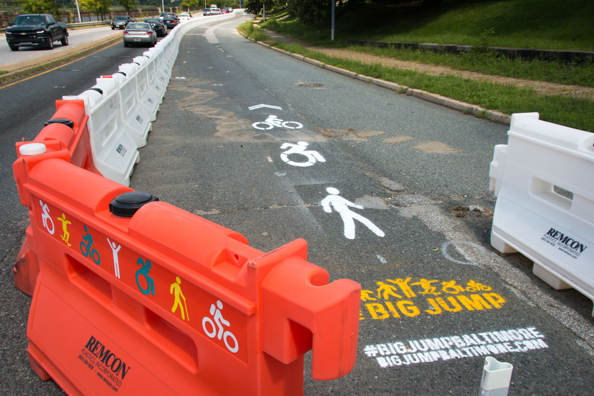
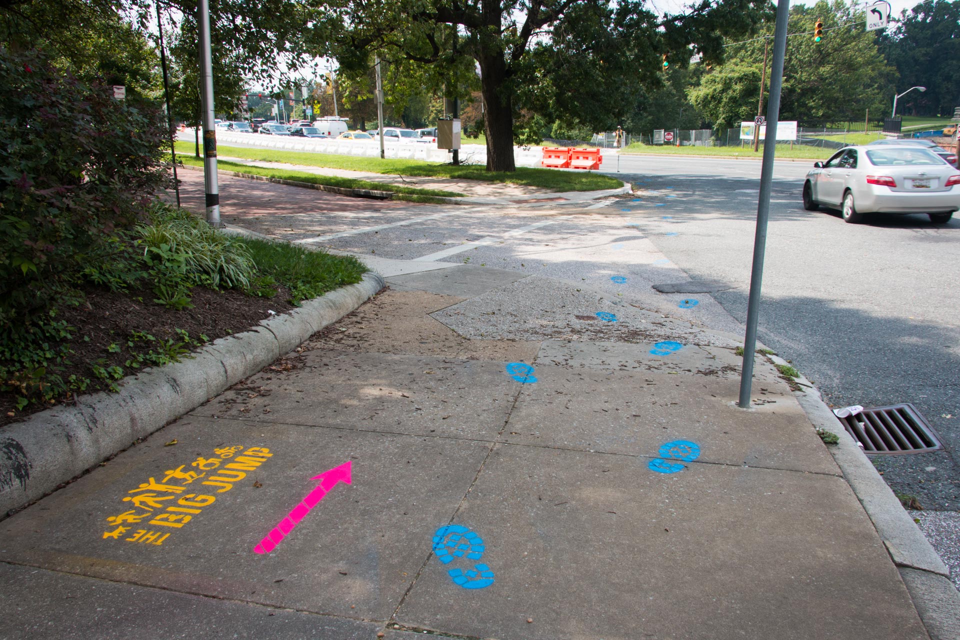
With the Big Jump temporary infrastructure now in place, myself and other residents and artists are adding public art enhancements making the trail more visible and usable for neighbors. In close collaboration with Bikemore, we’ve designed and installed creative wayfinding to show that the Big Jump Baltimore pathway is for everyone. Wayfinding consists of any number of sensory cues, such as signs, maps, textures and sounds, that provide travelers with orientation and possible paths. The Big Jump logo was designed by Danielle Parnes on behalf of Bikemore, with icon input from myself. I then adapted the logo to serve as pathway signage and wayfinding. For the Big Jump path we designed a street-sign-inspired logo featuring icons of the trail’s many different active uses, including but not limited to walking, wheelchair riding, bicycling dog walking, and skateboarding. We then went to our local makerspace Open Works and used their special equipment to cut the signage and icons out of adhesive backed, colorful vinyl. We used this cut vinyl to label and decorate the plastic jersey barriers so that both pedestrian and passing motorist can understand the purpose of the pathway.
To provide wayfinding for people not in cars we made our own set of large scale street stencils highlighting the pathway primary uses – walking, wheelchair riding, and bicycling. With these stencils we boldly marked the pathway as an active place for people. We also made several different footprint cutouts representing the people and creatures that travel daily between Druid Hill Park and surrounding neighborhoods. Stenciled with colorful traffic paint, these footprint trails visually lead residents from surrounding blocks to safe access points for the Big Jump Baltimore pathway and Druid Hill Park.
Local residents deserve priority access to Druid Hill Park. The Big Jump Baltimore shared use pathway shows that through low cost traffic projects, public art and community collaboration we can make immediate positive impact on the lives of our neighbors. For the first time ever wheelchair riders and people who rely on bicycles can actually cross the Jones Falls Expressway. More work needs to be done, but the Big Jump is a step in the right direction towards reconnecting our neighborhoods with Druid Hill Park. Starting in 2019 Baltimore City DOT will be conducting a roadway alignment study through which residents will have the opportunity to shape how the city converts the dangerous highways around Druid Hill Park into “complete streets”: streets safe and accessible for all, including pedestrians, children, seniors, mobility users, transit riders, and bicyclists. In the meantime, it’s up to us take advantage of the Big Jump pathway while to creatively envisioning how our neighborhoods will one day reconnect with Druid Hill Park.
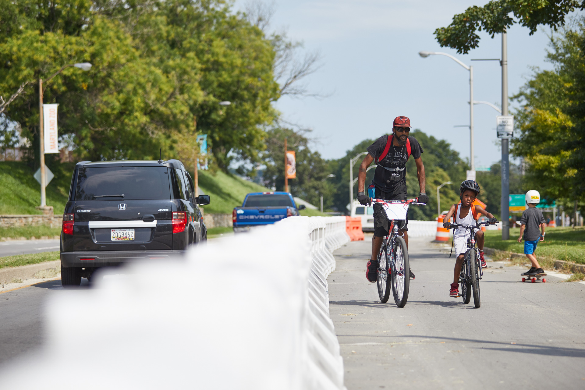
Big Jump father and son bicyclists, 9/26/18, photo by Brian O’Doherty
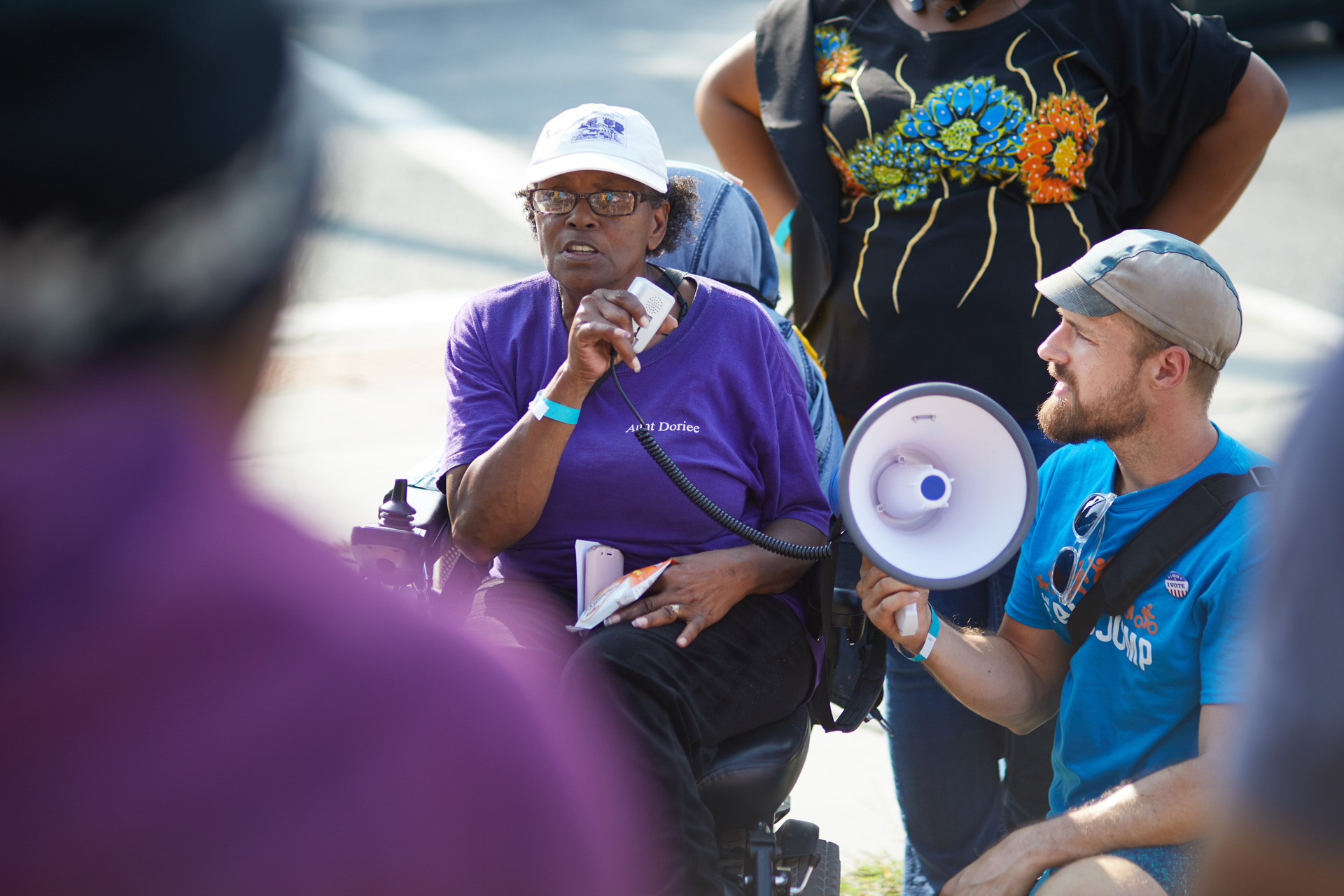
Big Jump Walking Tour 9/26/18 with Graham & Ms Dee, photo by Brian O’Doherty www.odohertyphoto.com
Memorial Pool, 1999, by Joyce J. Scott, photograph by Graham Coreil-Allen
Struggle and Joy in the Druid Hill Park Memorial Pool
By Graham Coreil-Allen
Originally Published in What Weekly, January 8, 2014
Edited by Marcus Civin
I recently moved in across the street from Druid Hill Park. A friend told me about a place little-known to neighborhood outsiders—a once abandoned public pool now filled in with dirt, covered in grass and framed with sumptuous, meandering walkways designed by celebrated Baltimore artist Joyce J. Scott. Wandering through the park on a warm, sunny afternoon, I discovered the large, rectangular grassy field framed by cobalt blue ceramic tiles, expansive marble steps and forgotten structures belonging to what was once Baltimore’s only segregation era public pool for African-Americans. Long cherished by generations of residents formerly restricted to only certain park facilities, the dignified yet understated Memorial Pool remains as a landscape of memory honoring the pride and struggles of Baltimore’s black community.
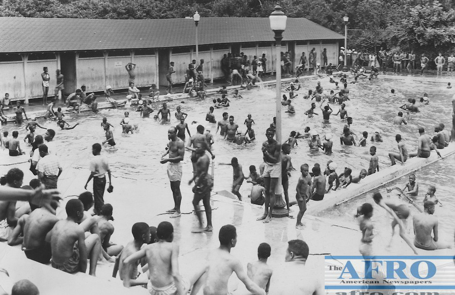
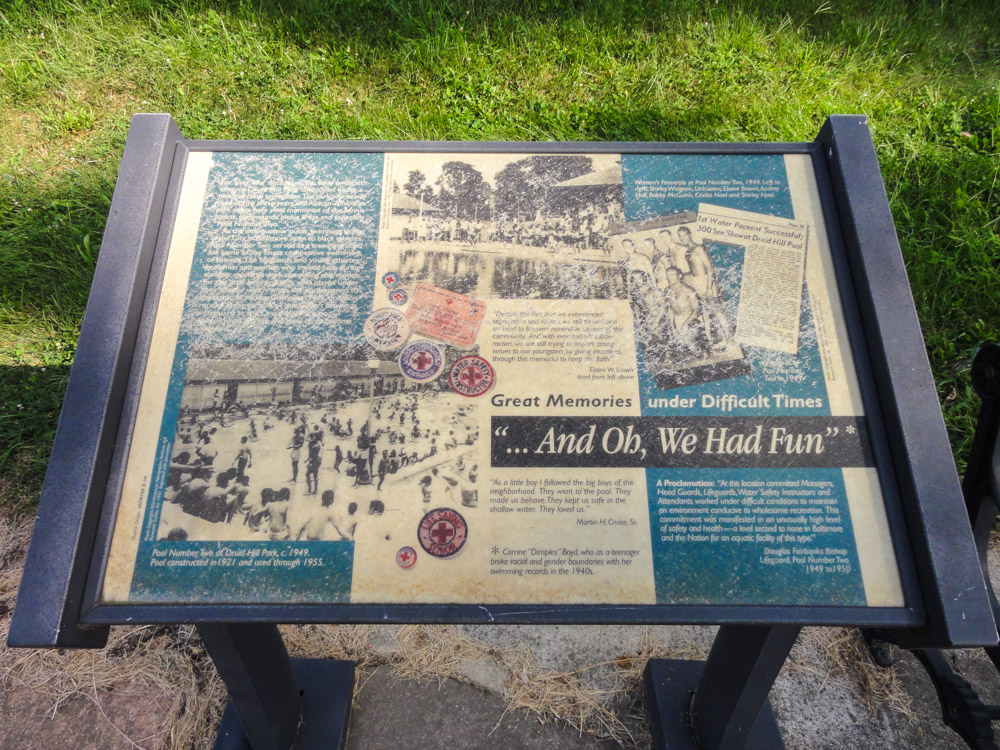
[Swimming pool], Druid Hill Park, Baltimore, undated, The Afro-American Newspapers Collection, via Project GadoNorth of the reservoir and east of the Jones Falls, the pool once anchored a larger complex of tennis courts, trees and a playground that collectively stood as Druid Hill Park’s only “negro” recreational facilities. The 100 foot by 105 foot “Pool No. 2”, as it was originally known, was built in 1921 to meet the recreational and competitive swimming needs of all of Baltimore’s hundreds of thousands of African-Americans. Elsewhere in the city, six separate public pools were well-maintained but off-limits to African-Americans. Despite being nearly half the size of the nearby, whites-only Pool No. 1, Pool No. 2 proved so popular that the crowds had to be admitted in shifts. Nevertheless, the patrons of color took pride in taking care of their grounds and keeping the area clean and attractive. The African-American competitive athletics society members that gathered around the space also showed off their finest in tennis fashion while meeting their future husbands and wives and socializing with friends and neighbors. Both the pool and surrounding segregated tennis courts were frequented by many of the era’s most accomplished black athletes. These visits and other aspects of Druid Hill Park’s history are noted on signs throughout the park and in books such as Eden Unger Bowditch’s Druid Hill Park: The Heart of Historic Baltimore.
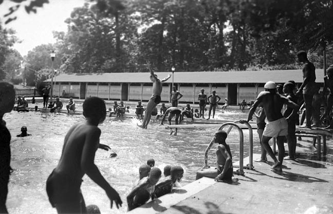
[Swimming pool], Druid Hill Park, Baltimore, August 1948, Paul Henderson, (1899-1988), 4×5 inch film negative. Baltimore City Life Museum Collection, HEN.01.03-013, via Maryland Historical Society PhotographsThings began to change in 1953 when an African-American boy accidentally drowned while swimming with friends in the Patapsco River. He lived near Clifton Park but was not allowed to swim in the park’s whites-only pool. For this reason it was thought that he chose to swim in the dangerous river feeding Baltimore Harbor’s Middle Branch. As a result, the NAACP pushed for all Baltimore municipal pools to be opened to all races. When the Parks Board refused, the NAACP filed a lawsuit, which they eventually won on appeal. On June 23, 1956, all of the city’s public pools were opened for the summer season on a non-segregated basis. That opening day, over 100 African-Americans reportedly braved the waters in Pool No. 1, while only one white person swam in Pool. No. 2. After that summer of transition, Pool No. 2 was closed for good in an effort to eliminate all vestiges of the city’s former “separate but equal” swimming infrastructure. After that point, all Druid Hill Park patrons wishing to swim had access to the twice-as-large and still existing Pool No. 1.
Forty years after Pool No. 2 closed, the concrete structure lay dangerously empty while the surrounding tennis courts stood in need of repair. Then, in the mid-nineties, park officials began talking with residents about what they most valued about Druid Hill Park. This was the research phase of the 1995 Druid Hill Park Master Plan. During this research phase, the planners discovered that local residents shared a strong sense of nostalgia for the historically African-American section of the park. In response, the adopted master plan called for, “a meditative, artistic, and informative setting acknowledging the segregation era at the site of the formerly “Negroe Pool”.” After a 1996 open call for proposals, Baltimore artist Joyce J. Scott was selected to redesign the pool as a place of reflection and celebration. By that point, Scott was well-known for her provocative, figurative beaded sculptures dealing with issues of race, class and gender. Growing up in Sandtown, Scott had frequented Druid Hill Park as a child and swam in the formerly whites-only pool. During an interview for this article, the artist shared with me some of her unrealized visions for the memorial design as well as her take on how the Memorial Pool’s symbolic and functional design represents the slow progress around issues of race and class in Baltimore. We also discussed the memorial as it exists today and it’s contextual surrounds in Druid Hill Park.
Memorial Pool, 1999, by Joyce J. Scott, photograph by Graham Coreil-Allen 130824
Memorial Pool, 1999, by Joyce J. Scott, photograph by Graham Coreil-Allen 130824
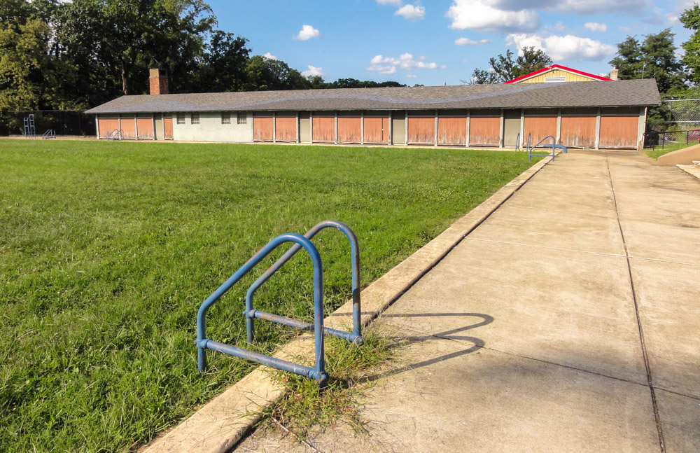
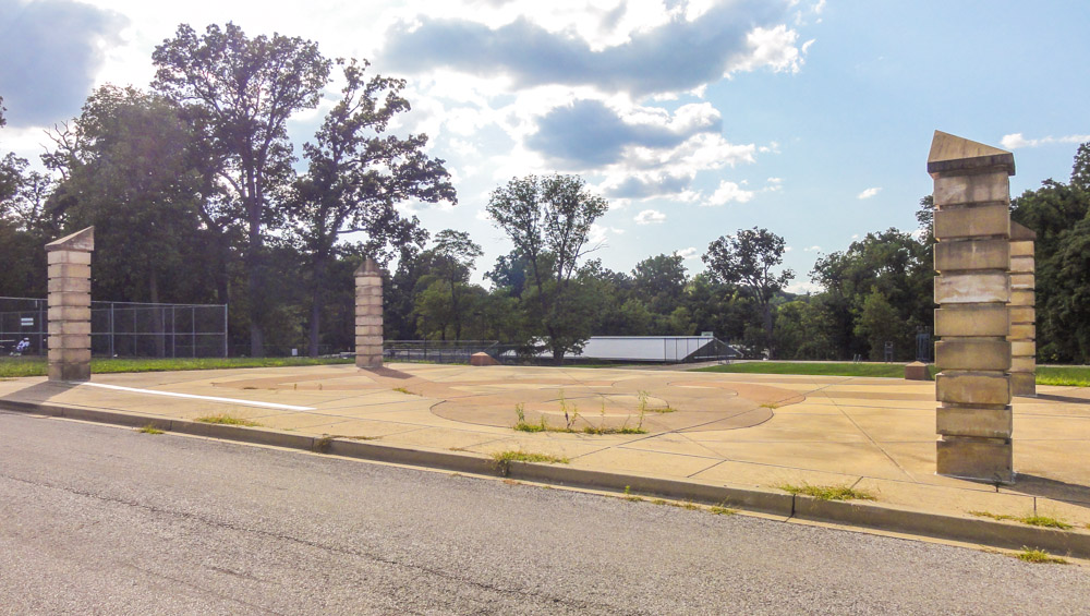
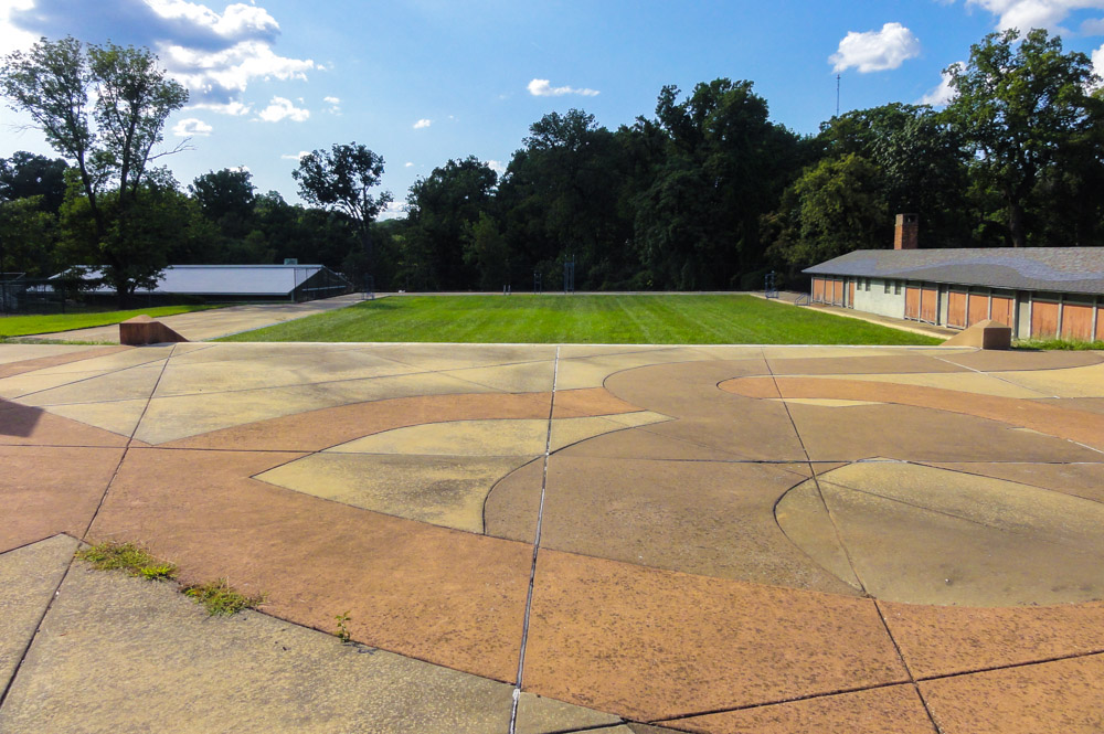
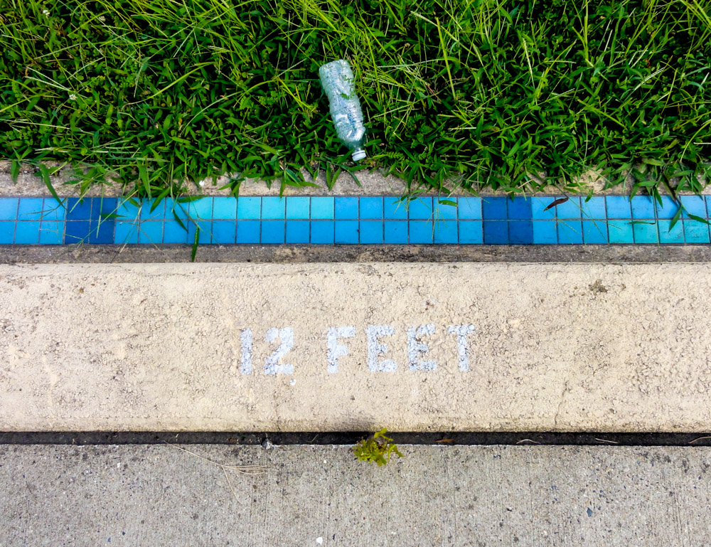
As its remains today, the now weathered Memorial Pool area continues to serve the tennis and recreational needs of hundreds of thousands of predominantly African-American park goers annually. Memorial Pool is on the southwest corner of Shop and Commissary Roads. The space is fronted by a wide, concrete pad embedded with large-scale, faded red and orange curvy concrete patterns framed by four square columns that consist of 24 inch square by 12 inch tall marble blocks stacked approximately nine feet tall and topped with diagonally sloped capitals that look like one corner of a pyramid. The chisel-topped columns suggest the outline of the old field house where pool tickets were once sold. A wide flight of marble steps leads to a 105 feet long by 100 feet wide rectangular expanse of grass resting approximately seven feet below street level.
Memorial Pool, 1999, by Joyce J. Scott, photograph by Graham Coreil-Allen 130824
Memorial Pool, 1999, by Joyce J. Scott, photograph by Graham Coreil-Allen 130824
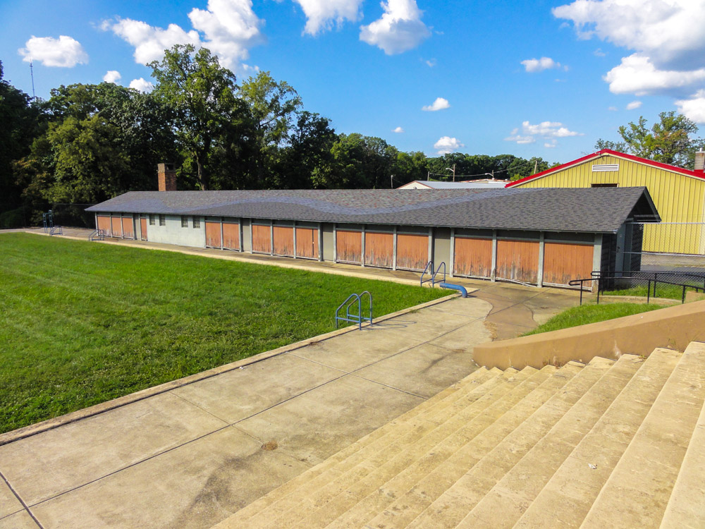
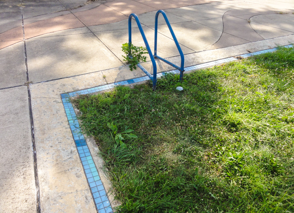
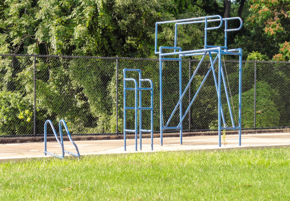
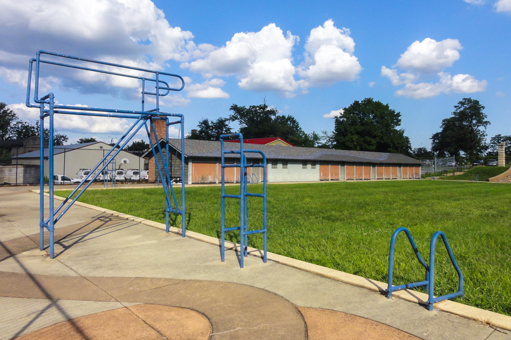
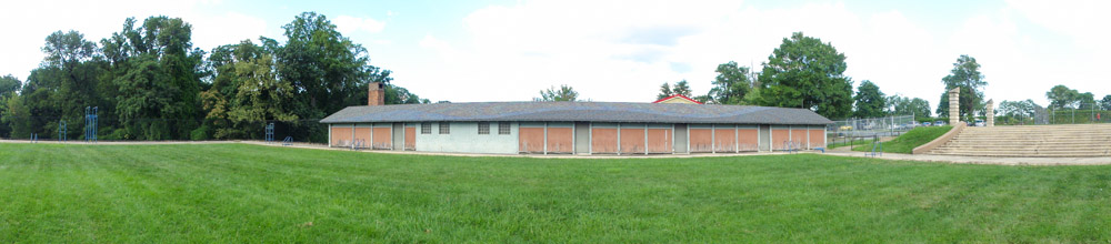
The grassy void is outlined by a thin perimeter of two rows of 2 inch square ” blue tiles surrounded by concrete sidewalks embedded with undulating patterns of orange, red and blue based on traditional African motifs representing peace, tranquility and community bonds. Around the blue perimeter tiles stand blue-painted armatures of the forlorn diving board; ladders and lifeguard stations that function as uncanny reminders of the space’s former aquatic use while also serving as skeletal sundials casting angular shadows across concrete and grass. Running parallel to the length of the pool’s north side stands a low-lying brown wooden building that used to house the men’s dressing rooms. The structure is topped with a black, pitched roof featuring a wave of blue roofing tiles symbolizing water. Around the void, the subtly colorful concrete pavement continues beyond the perimeter before turning into a meandering, southbound path accented by collections of cement-set riverstones. The river-like path connects the Memorial Pool to the nearby tennis courts, picnic grove and playground. Both ends of the path are marked with stanchions detailing the site’s rich history.
Memorial Pool, 1999, by Joyce J. Scott, photograph by Graham Coreil-Allen 130824
Memorial Pool, 1999, by Joyce J. Scott, photograph by Graham Coreil-Allen 130824
The entire site is surrounded on two sides by park maintenance facilities including loading docks, garages and trucks. On the other side of Shop Road, behind a small parking lot and two tennis courts, the historic St. Paul’s cemetery is in need of extensive restoration. The contextual contradictions and resonances of the Memorial Pool as a place of memory next to that same active loading dock and the crumbling cemetery were not lost on Joyce Scott when she approached the project in 1999. Scott first asked herself, “How do we make this area useful and beautiful, and harken back to the pool era?”
Memorial Pool, 1999, by Joyce J. Scott, photograph by Graham Coreil-Allen 130824
Memorial Pool, 1999, by Joyce J. Scott, photograph by Graham Coreil-Allen 130824In designing the functional monument, she states that her intent was to create an “art situation where people can go into space and hopefully be, and have a variety of uses.” Early on, there were plans to include programming in the grassy area, with the hope being that people would want to sit, picnic or just relax around the space. In addition to the architectural framing devices and aquatic symbolism, the original installation included abstract, colorful painted designs on the pavement around the pool that have since faded from the concrete surface and disappeared due to time and weather. Scott’s initial vision also included a series of metal tree sculptures embedded with clay panels and mirrors. These trees would have stood on the stony shoals of the river-like connecting path. In the end, the artist’s trees of reflection and remembrance were omitted from the plans after some members of the community expressed concern that the sculptures would have evoked lynching. While the artist strongly disagrees with this interpretation, at the time she thought it was best to acquiesce to the constituents’ concerns. By asking Scott to compromise her design, the neighbors may have unintentionally made the southern end of the memorial harder to recognize as a space of memory. In comparison to the northern end, the southern end of the memorial comes off more subtle in its overall presence, reading less like a public memorial and more like a creatively designed sidewalk with a historical marker.
For all that Pool No. 2 represents about the history of struggle over African-American access to public spaces in Baltimore, it seems inevitable that any attempt to memorialize the space would cause some controversy. But through her own vision and standing, Scott was able to effectively work with various city departments, the Maryland State Arts Council, and local community groups on creating a unique space of memory that honors the joys and struggles embedded in Druid Hill Park. The artist tells a story of how, back before desegregation, the white-only Pool No. 1 was unfiltered and connected directly to the reservoir, while the African-American Pool No. 2 was filtered in order to “de-negroize” the water to ensure the safety of the rest of the city. Inadvertently, this offensive policy resulted in a better experience for African-Americans. Scott succinctly states, “What was seen as a way of restraining someone only made them stronger.” She continues to explain that African-Americans in Baltimore responded to racist oppression by building up their own safe spaces and strong institutions. African-American strength was expressed through socializing, play and competition at the only pool offered by the city.
Memorial Pool, 1999, by Joyce J. Scott, photograph by Graham Coreil-Allen 130824
For me, the psychic presence remaining from the decades of aquatic joy and athletic gathering can no doubt be felt as I stand at the pool’s grassy, western edge, next to a diving board casting long afternoon shadows. For Scott, the Memorial Pool represents, “the sway and the slow change in our race history in our city that isn’t really that much of a change.” Indeed, as it lays today, the history, form and condition of the Memorial Pool makes a compelling, if at times concerning, analogy for Baltimore City as a whole. A brief stroll from Harbor East through the Inner Harbor and then into Lexington Market shows that while the city is much more racially integrated than it once was, it still remains intensely segregated, especially by class. Economic progress has been made in some areas while paint peels off in others. It’s through the Memorial Pool’s poignant contradictions of place and history that Scott reminds us of the inseparability between pleasure and strife. States the artist: “People have to remember that struggle and joy go hand in hand. You don’t many times understand the beauty of joy unless you go through a struggle.”
Memorial Pool, 1999, by Joyce J. Scott, photograph by Graham Coreil-Allen 130824